
Science Kit
Scientific Instrument
- Power Supplies and Transformers
- Training Kits for Communication Lab
- Digital Electronic Experiments Computer Principles
- Study of Multivibrators
- Characteristics Operational Amplifiers
- Verification of Network Theorem
- Amplifiers Kits
- Demonstration Models
- Verification of Various Laws and Conservation of Signal
- Semi Conductor Devices
- Laser Experiment
- Characteristics Of Vaccum Tubes
- E M Apparatus Instrument
- Microprocessors
- OPTO Electronic Devices Equipments
- Digital Measuring Instruments
- Nuclear Physics
- Test and Measuring Instruments
Biology Equipment
- Prepared Slides Equipments
- Plant Equipment
- Magnifier Equipment
- Animal Equipments
- Biotechnology Equipments
- Cell Equipments
- Classification Equipments
- Dissection Equipments
- Electrophoresis Equipments
- Enzyme Equipments
- Genetics and Inheritance Equipments
- Health Equipments
- Human Biology Equipments
- Microbiology Equipment
- Molecular Model Equipment
Best Lab Equipment
Educational Lab Equipment
Analytical Lab Instrument
- Electrochemistry Instruments
- Flame Photometer
- Pharmacology Instruments
- Tablet Making Machine
- Apparatus For Isolated Uterus Intestine
- Water Still
- B.O.D. Incubator
- Egg Incubator
- Incubator Bacteriological
- Drying Oven Industrial
- Hot Air Universal Oven
- Shaker
- Incubators
- Hot Plate
- Clean Air Equipments
- Baths
- Autoclaves
- Surveying Instruments
- Pipette Washer (Automatic)
- Tissue Homogeniser
- Moisture Meter
- Mortuary Chamber
- Soxhlet Extraction Unit
- Kjeldahl Units (Without Glass Part)
- pH Meters
- Conductivity Meter
- Salinity Meter
- Dissolved Oxygen Meters
- Turbidity Meters
- Colony Counter
- Moisture Titrator
- Fluorometer
- Dissolution Test Apparatus
- Friability Test Apparatus
- Pyrogen Testing Instrument
- Tap or Bulk Density Apparatus
- Leak Test Apparatus
- Flocculator Jar Test Apparatus
- Microprocessor Flame Photometers
- Pharmacy Laboratory Equipments
- Respiration Pumps
- Brodie Operating Tables
- Embalming Tables
- Rat Operating Tables
- Small Animal Operating Tables
- Animals Holders
- Animals Head Holders
- Pneumograph Stethographs
- Spirometers
- Benedict Roth Recording Spirometers
- Digital Respinometers
- Organ Baths
- Isolated Organ Baths Digitals
- Four Unit Organ Baths
- Perfusions Lagendroff Assembly
- Dubois Raymond Keys
- Simple Keys
- Induction Coils
- Student Induction Coils
- Variable Interrupters
- Mosses Ergographs
- Compass Aesthesiometers
- Hand Grip Dynamometers
- Skin Fold Calipers
- Macerators
- Tablet Polishing Pans
- Tablet Making Machines (Electrically Operated)
- Tablets Making Machine Motorised
- Tablets Making Machine Hand Operated
- Apparatus Isolated Uterus Intestine
- Clean Air Benches
- Bio Safety Cabinet
- Laboratory Fume Hoods
- Fumigation
- Environmental Growth Chamber
- Ovens
- Water Distillation Plant
- Water Baths
- Hot Plates Warming Tables
- Dry Block Digester
- Shaking Machines And Stirrers
- COD Digester
- General Laboratory Equipment
- Spectrophotometer
- pharmaceutical-instruments/Pharmacology Equipments
Laboratory Apparatus
Laboratory Equipments Supplies
Engineering Lab Equipment
- Metallurgical Equipment
- Survey Instruments
- Incinerator
- Razor Sharpener
- Heat Transfer Lab Equipment
- Fluid Mechanics Lab Equipment
- Civil Engineering Lab Equipment
- Charts
- Bottle Top Dispenser
- Adsorption in Packed Beds
- Botany Charts
- Zoology Chart
- Chemistry Charts
- Physics Charts
- General Science Charts
- Genetics and Evolution Charts
- Human Physiology Charts
- Life Sketch of Scientists
- Food And Nutrition
- Health Care Series
- Prevent Diseases
- First Aid Charts
- Yogasana Charts
- Mathematics Primary Charts
- Charts on Geography
- Changing Face of the Earth
- Man and Environment
- Weather Maps of India
- Alphabet Charts
- Special Charts
- Moral Story Charts
- Specials Roll ups
- Struggle For Indian Freedom
- National Integration Charts
- Life Sketch of Great Men
- English Teaching Charts
- English Grammar Charts
- Military Science
- Army, Police and NCC Charts
- Maps Charts
- State Maps Political
- Civil and Draughtsman Equipment
- Nautical Compass
- Survey Equipment
- Soil Testing Equipments
- Measuring Instruments
- Tripods Stands
- Portholes
- Nautical Sextants
- Prism Sets
- CNC Trainer Machine
- Training Workshop Labs
- Mechanical Engineering Lab Equipment
- Air Conditioning and Refrigeration
- Automotive and Transportation
- Building Material Testing
Maths Lab Equipment
Porcelain Ware
Hospital Lab Equipments
Anatomical Models
- Dental Models
- Skeletons For Medical Students
- ENT Models
- Cancer Model
- Diabetes Model
- Implant Models
- Brain Models, Neuro Models
- Liver and Gastro Models
- Gynae Models, Female Health, Utreus Models
- Four Stage Liver Models
- Special Models
- Arthritis Models
- Heart and Artery Models
- Ortho Models
- Heart and Lungs Models
- Nurse Training Models
- Life Support Training Models
- Human Models
- Anatomical Models Equipments
Vocational Training Laboratory Equipment
- Woodworking Workshop Machines
- Wood Workshop Portable Tool
- Plant Engineering and Welding Equipment
- Welding Equipment and Workshop Lab Machine
- Standard Welding Equipment Set
- Electrical Work Bench
- Workshop Tools
- Plumbing Workshop Instrument
- Concrete Laboratory
- Soil Mechanics
- Hydraulics and Pneumatics
- Metal Manufacturing Training Machine
- Washing Machines
- Textile Technology
Lab Glassware
- Watch Glass Soda
- Voltameters
- Stirrers
- Test Tubes and Thermometer Pockets
- Staining Jars Glassware
- Specimen Tubes and Vials
- Spirit Burners
- Screwthreads, Discs and Joints
- Screw Caps, Stoppers and Stopcocks
- Distillation
- Extractors
- Coplins Jars
- Condenser
- Chromatography Columns
- Bends
- Beakers and Flasks
- Laboratory Adapter Oscilloscope Kit
Electronics Lab Equipments
- Variac Dimmerstats
- Signal Generators
- Fiber Optic Trainers
- Digital Storage Oscilloscopes
- Digital Electronics Trainer
- Communication Trainer
- Breadboard Trainers
- Analog Electronics Trainer
- Oscilloscopes
- Power Electronics Trainers
- Electronic Fundamentals
- Audio and Visual Technology
- Radio and Telephone Communications
- Electrical Technology
- Wiring, Distribution and Protection
- Electrical Motor Control
- Data Acquisition, Instrumentation and Process Control
- Lighting and Building Control Systems
Lab Plasticware
Chemistry Lab Equipment
Physics Lab Equipment
- Measurement
- Magnetisms
- Heat
- AP Physics
- Physics Lab Equipments
- Atomic Physics Equipment
- Density Equipment
- Electricity Equipment
- Electromagnetism Equipment
- Electrostatics Equipment
- Energy Transfer Equipment
- Force Motion & Dynamic Equipment
- Mechanics Lab Equipment
- Light & Optics Equipment
- Renewable Energy Equipment
- Sound and Waves
- Education Kit
Geography Lab Models
State Maps Political Manufacturer, Suppliers and Exporter in India
Jaincolab Manufacturers is leading State Maps Political Manufacturer,and supplier and Exporter in India, Algeria (Algiers), Angola (Luanda), Argentina (Buenos Aires), Armenia (Yerevan), Australia(Canberra), Austria (Vienna), Bahrain (Manama), Bangladesh (Dhaka), Bhutan (Thimphu), Bolivia (Sucre), Botswana (Gaborone), Brazil (Brasília), Brunei (Bandar Seri Begawan), Montenegro (Podgorica), Morocco (Rabat), Mozambique (Maputo), Myanmar (Naypyidaw), Namibia (Windhoek), Nepal (Kathmandu), New Zealand (Wellington), Nigeria (Abuja), Oman (Muscat), Palestine (Ramallah), Panama (Panama City), Papua New Guinea (Port Moresby), Paraguay (Asunción), Peru (Lima), Philippines (Manila)¸ Portugal (Lisbon), Qatar (Doha), Rwanda (Kigali), Saudi Arabia (Riyadh), Senegal (Dakar), Serbia (Belgrade), Sierra Leone (Freetown), Slovakia (Bratislava), South Africa (Cape Town) (Pretoria) (Bloemfontein), South Sudan (Juba), Spain (Madrid), Sri Lanka (Sri Jayawardenepura Kotte) (Colombo), Sudan (Khartoum), Syria (Damascus), Tanzania (Dodoma), Thailand (Bangkok), Togo (Lomé), Tonga (Nuku'alofa), Trinidad and Tobago (Port of Spain), Tunisia (Tunis), Turkey (Ankara), Turkmenistan (Ashgabat), Uganda (Kampala), United Arab Emirates (Abu Dhabi), United Kingdom (London), United States (Washington, D.C.)
Jainco Lab presents itself as a prime State Maps Political Manufacturer, Supplier, and Exporter in India, recognized for offering low-cost, affordable, tender-ready, and supportive wholesalers for educational maps meant for schools, colleges, and government institutions. All political maps at Jainco Lab are manufactured with ISO 9001 quality management and 14001 environmental safety systems. Jainco Lab exports political maps at the state level to 80+ different nations in Southern Asia, the Middle East, Africa, Europe, and North America. All political boundaries, capital points, and administrative sections are carefully created with due consideration for reliable academic sources, including Geographical Review, and reliable Wikipedia articles like ‘States and union territories of India.’
The Maharashtra State Political Map meets ISO 216 size standards and uses CE-approved printing inks, promoting proper handling and clear delimitation. The Karnataka State Political Map maintains ISO 2846 color calibration standards, properly distinguishing among the regions. The Uttar Pradesh State Political Map remains within RoHS norms on materials, making it completely non-toxic for lamination. The Gujarat State Political Map maintains typographic guidelines on ISO 5426, providing extra-clear labeling and legends. The Rajasthan State Political Map contains child-safe materials on EN 71 standards, making it perfect for learning environments at all school levels. The Tamil Nadu State Political Map maintains consistency on ISO 12647, ensuring stable color standards. The West Bengal State Political Map uses archival-grade paper on ISO 9706 standards, encoded for preservation. The Punjab State Political Map uses approved coatings on REACH, minimizing hazardous contact. The Kerala State Political Map complies with guidelines on ISO 7010, clearly separating districts. The Haryana State Political Map uses safety-certified substrates on EN 62368 standards, promoting universal safety for global distribution.
Jainco Lab unites ISO procedures, CE compliance, and fulfillment of RoHS and REACH regulations with EN approval for material safety on all state political maps. It leads to accurate, permanent, and internationally recognized educational diagrams endorsed by teachers, schools, and distributors.

Assam and N.E. States Chart
Product Code : JA-SMP-3306
Showing latest boundaries Political features:- Capital cities and important towns
View Details
Andhra Pradesh Political Chart
Product Code : JA-SMP-3307
Capital cities and important towns. Certified by Survey of India. Size:- 70 x 100 cm.
View Details
Bihar Political Cum Physical Chart
Product Code : JA-SMP-3308
Showing latest boundaries. Capital cities and important towns.
View Details
Chhattisgarh Chart
Product Code : JA-SMP-3309
Showing latest boundaries Capital cities and important towns
View Details
Delhi Political Chart
Product Code : JA-SMP-3310
Showing latest boundaries Political features Capital cities and important towns
View Details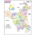
Haryana Map Chart
Product Code : JA-SMP-3311
Showing latest boundaries Capital cities and important towns Certified by Survey of India
View Details
Himachal Pradesh Map Chart
Product Code : JA-SMP-3312
Showing latest boundaries Political features:- Capital cities and important towns
View Details
Karnataka Political Map Chart
Product Code : JA-SMP-3313
Showing latest boundaries. Capital cities and important towns. Certified by Survey of India.
View Details
Kerala Political Map Chart
Product Code : JA-SMP-3314
Showing latest boundaries. Capital cities and important towns. Certified by Survey of India.
View Details
Punjab Political Map Chart
Product Code : JA-SMP-3315
Showing latest boundaries Capital cities and important towns
View Details
Rajasthan Political Map Chart
Product Code : JA-SMP-3316
Showing latest boundaries. Capital cities and important towns.
View Details
Tamil Nadu Chart
Product Code : JA-SMP-3317
Showing latest boundaries Capital cities and important towns
View Details
Uttar Pradesh Political Map Chart
Product Code : JA-SMP-3318
Showing latest boundaries Capital cities and important towns Certified by Survey of India
View Details
Uttarakhand Political Map Chart
Product Code : JA-SMP-3319
Showing latest boundaries Capital cities and important towns Certified by Survey of India
View Details
West Bengal Political Map Chart
Product Code : JA-SMP-3320
Showing latest boundaries Capital cities and important towns
View Details
