
Science Kit
Scientific Instrument
- Power Supplies and Transformers
- Training Kits for Communication Lab
- Digital Electronic Experiments Computer Principles
- Study of Multivibrators
- Characteristics Operational Amplifiers
- Verification of Network Theorem
- Amplifiers Kits
- Demonstration Models
- Verification of Various Laws and Conservation of Signal
- Semi Conductor Devices
- Laser Experiment
- Characteristics Of Vaccum Tubes
- E M Apparatus Instrument
- Microprocessors
- OPTO Electronic Devices Equipments
- Digital Measuring Instruments
- Nuclear Physics
- Test and Measuring Instruments
Biology Equipment
- Prepared Slides Equipments
- Plant Equipment
- Magnifier Equipment
- Animal Equipments
- Biotechnology Equipments
- Cell Equipments
- Classification Equipments
- Dissection Equipments
- Electrophoresis Equipments
- Enzyme Equipments
- Genetics and Inheritance Equipments
- Health Equipments
- Human Biology Equipments
- Microbiology Equipment
- Molecular Model Equipment
Best Lab Equipment
Educational Lab Equipment
Analytical Lab Instrument
- Electrochemistry Instruments
- Flame Photometer
- Pharmacology Instruments
- Tablet Making Machine
- Apparatus For Isolated Uterus Intestine
- Water Still
- B.O.D. Incubator
- Egg Incubator
- Incubator Bacteriological
- Drying Oven Industrial
- Hot Air Universal Oven
- Shaker
- Incubators
- Hot Plate
- Clean Air Equipments
- Baths
- Autoclaves
- Surveying Instruments
- Pipette Washer (Automatic)
- Tissue Homogeniser
- Moisture Meter
- Mortuary Chamber
- Soxhlet Extraction Unit
- Kjeldahl Units (Without Glass Part)
- pH Meters
- Conductivity Meter
- Salinity Meter
- Dissolved Oxygen Meters
- Turbidity Meters
- Colony Counter
- Moisture Titrator
- Fluorometer
- Dissolution Test Apparatus
- Friability Test Apparatus
- Pyrogen Testing Instrument
- Tap or Bulk Density Apparatus
- Leak Test Apparatus
- Flocculator Jar Test Apparatus
- Microprocessor Flame Photometers
- Pharmacy Laboratory Equipments
- Respiration Pumps
- Brodie Operating Tables
- Embalming Tables
- Rat Operating Tables
- Small Animal Operating Tables
- Animals Holders
- Animals Head Holders
- Pneumograph Stethographs
- Spirometers
- Benedict Roth Recording Spirometers
- Digital Respinometers
- Organ Baths
- Isolated Organ Baths Digitals
- Four Unit Organ Baths
- Perfusions Lagendroff Assembly
- Dubois Raymond Keys
- Simple Keys
- Induction Coils
- Student Induction Coils
- Variable Interrupters
- Mosses Ergographs
- Compass Aesthesiometers
- Hand Grip Dynamometers
- Skin Fold Calipers
- Macerators
- Tablet Polishing Pans
- Tablet Making Machines (Electrically Operated)
- Tablets Making Machine Motorised
- Tablets Making Machine Hand Operated
- Apparatus Isolated Uterus Intestine
- Clean Air Benches
- Bio Safety Cabinet
- Laboratory Fume Hoods
- Fumigation
- Environmental Growth Chamber
- Ovens
- Water Distillation Plant
- Water Baths
- Hot Plates Warming Tables
- Dry Block Digester
- Shaking Machines And Stirrers
- COD Digester
- General Laboratory Equipment
- Spectrophotometer
- pharmaceutical-instruments/Pharmacology Equipments
Laboratory Apparatus
Laboratory Equipments Supplies
Engineering Lab Equipment
- Metallurgical Equipment
- Survey Instruments
- Incinerator
- Razor Sharpener
- Heat Transfer Lab Equipment
- Fluid Mechanics Lab Equipment
- Civil Engineering Lab Equipment
- Charts
- Bottle Top Dispenser
- Adsorption in Packed Beds
- Botany Charts
- Zoology Chart
- Chemistry Charts
- Physics Charts
- General Science Charts
- Genetics and Evolution Charts
- Human Physiology Charts
- Life Sketch of Scientists
- Food And Nutrition
- Health Care Series
- Prevent Diseases
- First Aid Charts
- Yogasana Charts
- Mathematics Primary Charts
- Charts on Geography
- Changing Face of the Earth
- Man and Environment
- Weather Maps of India
- Alphabet Charts
- Special Charts
- Moral Story Charts
- Specials Roll ups
- Struggle For Indian Freedom
- National Integration Charts
- Life Sketch of Great Men
- English Teaching Charts
- English Grammar Charts
- Military Science
- Army, Police and NCC Charts
- Maps Charts
- State Maps Political
- Civil and Draughtsman Equipment
- Nautical Compass
- Survey Equipment
- Soil Testing Equipments
- Measuring Instruments
- Tripods Stands
- Portholes
- Nautical Sextants
- Prism Sets
- CNC Trainer Machine
- Training Workshop Labs
- Mechanical Engineering Lab Equipment
- Air Conditioning and Refrigeration
- Automotive and Transportation
- Building Material Testing
Maths Lab Equipment
Porcelain Ware
Hospital Lab Equipments
Anatomical Models
- Dental Models
- Skeletons For Medical Students
- ENT Models
- Cancer Model
- Diabetes Model
- Implant Models
- Brain Models, Neuro Models
- Liver and Gastro Models
- Gynae Models, Female Health, Utreus Models
- Four Stage Liver Models
- Special Models
- Arthritis Models
- Heart and Artery Models
- Ortho Models
- Heart and Lungs Models
- Nurse Training Models
- Life Support Training Models
- Human Models
- Anatomical Models Equipments
Vocational Training Laboratory Equipment
- Woodworking Workshop Machines
- Wood Workshop Portable Tool
- Plant Engineering and Welding Equipment
- Welding Equipment and Workshop Lab Machine
- Standard Welding Equipment Set
- Electrical Work Bench
- Workshop Tools
- Plumbing Workshop Instrument
- Concrete Laboratory
- Soil Mechanics
- Hydraulics and Pneumatics
- Metal Manufacturing Training Machine
- Washing Machines
- Textile Technology
Lab Glassware
- Watch Glass Soda
- Voltameters
- Stirrers
- Test Tubes and Thermometer Pockets
- Staining Jars Glassware
- Specimen Tubes and Vials
- Spirit Burners
- Screwthreads, Discs and Joints
- Screw Caps, Stoppers and Stopcocks
- Distillation
- Extractors
- Coplins Jars
- Condenser
- Chromatography Columns
- Bends
- Beakers and Flasks
- Laboratory Adapter Oscilloscope Kit
Electronics Lab Equipments
- Variac Dimmerstats
- Signal Generators
- Fiber Optic Trainers
- Digital Storage Oscilloscopes
- Digital Electronics Trainer
- Communication Trainer
- Breadboard Trainers
- Analog Electronics Trainer
- Oscilloscopes
- Power Electronics Trainers
- Electronic Fundamentals
- Audio and Visual Technology
- Radio and Telephone Communications
- Electrical Technology
- Wiring, Distribution and Protection
- Electrical Motor Control
- Data Acquisition, Instrumentation and Process Control
- Lighting and Building Control Systems
Lab Plasticware
Chemistry Lab Equipment
Physics Lab Equipment
- Measurement
- Magnetisms
- Heat
- AP Physics
- Physics Lab Equipments
- Atomic Physics Equipment
- Density Equipment
- Electricity Equipment
- Electromagnetism Equipment
- Electrostatics Equipment
- Energy Transfer Equipment
- Force Motion & Dynamic Equipment
- Mechanics Lab Equipment
- Light & Optics Equipment
- Renewable Energy Equipment
- Sound and Waves
- Education Kit
Geography Lab Models
Changing Face of the Earth Manufacturer, Suppliers and Exporter in India
Jaincolab Manufacturers is leading Changing Face of the Earth Manufacturer,and supplier and Exporter in India, Algeria (Algiers), Angola (Luanda), Argentina (Buenos Aires), Armenia (Yerevan), Australia(Canberra), Austria (Vienna), Bahrain (Manama), Bangladesh (Dhaka), Bhutan (Thimphu), Bolivia (Sucre), Botswana (Gaborone), Brazil (Brasília), Brunei (Bandar Seri Begawan), Montenegro (Podgorica), Morocco (Rabat), Mozambique (Maputo), Myanmar (Naypyidaw), Namibia (Windhoek), Nepal (Kathmandu), New Zealand (Wellington), Nigeria (Abuja), Oman (Muscat), Palestine (Ramallah), Panama (Panama City), Papua New Guinea (Port Moresby), Paraguay (Asunción), Peru (Lima), Philippines (Manila)¸ Portugal (Lisbon), Qatar (Doha), Rwanda (Kigali), Saudi Arabia (Riyadh), Senegal (Dakar), Serbia (Belgrade), Sierra Leone (Freetown), Slovakia (Bratislava), South Africa (Cape Town) (Pretoria) (Bloemfontein), South Sudan (Juba), Spain (Madrid), Sri Lanka (Sri Jayawardenepura Kotte) (Colombo), Sudan (Khartoum), Syria (Damascus), Tanzania (Dodoma), Thailand (Bangkok), Togo (Lomé), Tonga (Nuku'alofa), Trinidad and Tobago (Port of Spain), Tunisia (Tunis), Turkey (Ankara), Turkmenistan (Ashgabat), Uganda (Kampala), United Arab Emirates (Abu Dhabi), United Kingdom (London), United States (Washington, D.C.)
Jainco Lab is the largest Changing Face of the Earth Charts manufacturers, suppliers, and exporters in India, offering cheap, affordable, tender-ready, and wholesaler-friendly educational charts for schools, colleges, geography labs, and environmental education programs. Our production facility follows ISO 9001 for quality management and ISO 14001 for environmental compliance to ensure reliable and consistent outputs for bulk institutional and international orders. Jainco Lab exports its products to more than 80+ countries across Southern Asia, the Middle East, Africa, Europe, and North America. The content of our charts is based on verified sources, including peer-reviewed research published in journals, such as Journal of Environmental Geography, authoritative entries on Wikipedia, like "Earth science," "Geomorphology," and "Plate tectonics," to create scientifically accurate and curriculum-aligned visuals.
Our Changing Face of the Earth Charts include the Erosion and Deposition Chart follows ISO 216 paper dimension standards with CE-compliant non-toxic inks for safe classroom use. The Volcano Formation Chart meets ISO 9706 permanence standards for long-lasting durability. The Earthquake Impact Chart is printed under EN 71 child-safe material compliance. The Glacial Landforms Chart adheres to ISO 5426 typographic clarity standards, ensuring readable annotations. The River Meanders Chart is laminated under REACH-certified chemical-safe coating. The Coastal Changes Chart uses ISO 2846 colour accuracy standards, maintaining precise visual representation. The Desertification Chart follows ISO 12647 print consistency standards for uniform copies. The Landslide Processes Chart meets CE conformity for safe display in classrooms. The Tectonic Plate Movements Chart complies with EN 62368 material safety logic. The Weathering and Soil Formation Chart is produced under ISO 7010 hazard signage standards. The Flood Zones Chart uses RoHS-restricted materials, avoiding hazardous substances. The Ocean Currents Impact Chart adheres to ISO 12620 terminology accuracy standards. The Deforestation and Land Use Change Chart follows ISO 9706 archival standards, ensuring long-term readability. The Mountain Formation Chart is laminated with REACH-approved coatings, and the Climate Change Effects Chart meets CE and EN 71 safety compliance.
All Jainco Lab Changing Face of the Earth Charts are manufactured under traceable ISO-audited workflows with CE conformity, EN/ISO print and safety standards, RoHS/REACH-compliant materials, and controlled colour and permanence quality. This guarantees that the charts are non-toxic, long-lasting, curriculum-compatible, and fit for long-term classroom, laboratory, and international institutional use.

Rivers Landscape Chart
Product Code : JA-CFOTE-3143
Erosion landforms, Depositional landforms Printed in multi color on 80 gsm map litho paper
View Details
Sea Water Map
Product Code : JA-CFOTE-3144
Erosion, Transportation of the particles & deposition of the eroded material
View Details
Glacial Landform Chart
Product Code : JA-CFOTE-3140
Creation of landforms due to erosion, transportation and deposition. Printed in multicolour on 80 gsm map litho paper.
View Details
Coastal Landscape Chart
Product Code : JA-CFOTE-3141
Showing different figures and diagrams made by Sea Water. Printed in multicolour on 80 gsm map litho paper.
View Details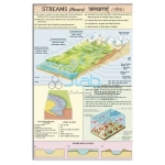
Streams (Rivers) Charts
Product Code : JA-CFOTE-3142
How a stream is formed and functions-collecting system, transporting system and dispersing system.
View Details
Wind Eolian System Chart
Product Code : JA-CFOTE-3145
Showing the parameters how wind acts on the Earth's surface. Printed in multicolour on 80 gsm map litho paper.
View Details
Glaciers Information Chart
Product Code : JA-CFOTE-3146
Continental Glacier, Piedmont Glacier & Valley Glacier together with their effects. Printed in multicolour on 80 gsm map litho paper.
View Details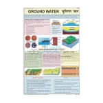
Ground Water Information Chart
Product Code : JA-CFOTE-3147
Zone of Aeration, Water Table, Zone saturation Printed in multicolour on 80 gsm map litho paper
View Details
Denudation Chart
Product Code : JA-CFOTE-3148
Showing weathering, chemical and physical effects of Erosion. Printed in multicolour on 80 gsm map litho paper.
View Details